By Ishraqa Abbas
August 17, 2018
When our polite tour guide at the Grand Addis Ababa Hotel told us that our trip to the source of the Blue Nile (the Blue Nile gorge) would be exciting and enjoyable, it never came to my mind it could be that horrible and tiring; and that I would be one of the few people who had ever trodden into those rough, fearful, but beautiful terrains at the same time. It was my conviction that my experiment on this road would be my strongest and would be carved in my memory as long as I lived.
THE NILE BASIN INITIATIVE
The story of this trip began when the Nile Basin Initiative invited us to attend a technical workshop on how to promote the role of women in the Nile Basin.
We assembled in the early morning at the hotel lobby. We were a group of 35 women from different walks of life in nine Nile Basin states. There were a few men among the group who pursued different occupations within the Initiative.
It was a joyous start; the weather was fine and the place captivating. We thought it would be like any other tourist trip that would in no time take us to the sources of the Blue Nile where we could find a place well prepared to receive tourists. But very soon we came to realize that that was not the case.
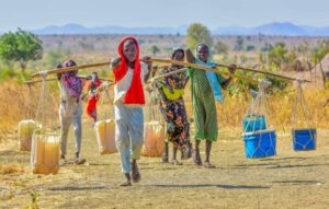
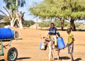
ABJECT POVERTY
The small cars gently took us outside the bewitching City of Addis Ababa and its moderate but relatively chilly weather and then descended from the City’s plateau towards Ethiopia’s North-West, where the Blue Nile River starts and then flows down its valley. So touching was the beauty of the road if it were not marred with the symptoms of poverty represented in scenes of elderly women carrying loads of firewood on their bent backs, their faces up as they ascended the rough sidewalks towards where they lived.
A STEEP SLOPE
Little by little the land tended to shrink and narrow in front of us and the beauty of nature in the flat valley grew into a portrait of solemn beauty. After we were driving on flat land we started to go down on masses of rock. Clamor and shouting that flew from inside the vehicle started to subside little by little, as if everybody had realized all of a sudden that the situation was not as before. The vehicle began to run down very quickly through narrow lanes cut in a chain of mountains. The guide told us that we were going down a slope, 2000 meters above the sea level that the slope would drop down to 600 meters and then to just 500 meters at the border of Sudan.
While my hands were holding fast on the seat in front of me, as if trying to prevent the car from falling into the precipice, I could not prevent myself from looking at the mountains. The scene seemed an incarnation of the verse in the Koran that: “We made the mountains as stakes for the Earth.” It seemed to me that mountains around us were part of a big stake fixed inside the Earth, a long mountain under the Earth’s crust and indeed a great creation. My imagination could not absorb how great is the Almighty’s creation in this part of the Earth, which could be of great significance in the Earth’s formation. Or maybe it is one of the corners of the Earth, one of its pillars. That thought had crystallized further in my mind when I remembered that the Blue Nile begins somewhere here and that the adage that the Nile is a descendent of heavens is true: The Nile outflows from paradise and not from the Earth!
The deeper we went into the mountains, the steeper the land became and the more our guide gave us a description of the topography around us. The guide pointed towards a road where trucks meandered down, saying it leads to Sudan. Then everybody turned to the guide as he said we were about to reach the Blue Nile Valley. We expectantly turned our heads towards a narrow bridge straddling two mountains that cannot allow but a single vehicle to pass at a time. We kept viewing the bridge as a savior from the panic that muted us. Out of my anxiety, i had a feeling that the closer we drew towards the bridge, the farther it moved from us.
IT IS NOT BLUE!
As soon as we reached the bridge, the guide raised his voice saying: “This is the Blue Nile Valley and those mountains on the other side are where it starts.”
Our heads were turned into wide eyes, as if we, all of us, expected something different and said in one voice: “But it is not blue!” Its water was turbid, as if mixed with clay, and its valley was narrow and calm. It is a wonder how this could turn into a high, noisy and thunderous river that spreads life wherever it flew and animates dead lands into fascinating beauty.
The Blue Nile source is a small river, 100 kilometers South of Lake Tana. It is lies about 2900 meters above sea level. It feeds Abaya River, also known as Abaya Lake that flows into Lake Tana, with an area of 3000 square kilometers and with a total depth of 15 meters. It is Ethiopia’s biggest lake. The Tana basin is fed by the perennial rivers Magech, Reb and Gumara in addition to other tributaries.
Lake Tana feeds the Blue Nile with an approximate 7 percent of its waters, according to Prof. Saifeddin Hammad Abdallah, the former manager of Sudan’s hydrological research station, member of Sudan’s negotiating team on Nile waters, the Nile and water expert.
SUDANESE DESIGNATION
Prof. Saifeddin says the name ‘Blue Nile’ was given to the River by Sudanese who call everything which is dark in color ‘Azraq(Blue). They called this Nile blue because of its dark turbid color due to the heavy silt it carries, in comparison with the White Nile that seems clear. The Ethiopians call the Blue Nile Abay that means ‘father’ in Amharic.
The Blue Nile flows for 30 kilometer from Lake Tana’s South West point to Tisisiat waterfalls and then enters a 1200 meter deep 400 kilometer long rift before it flows to the Southeast to cross western Ethiopia into Sudan. The rivers Bele, Bashilo, and Jamma flow into the Blue Nile’s upper zones while the rivers Didessa, Dabus and Beles flow into its lower zones. The River Didessa provides the Blue Nile with one fourth of its water. The Ethiopian Plateau provides the Nile with 85 percent of its waters, according to Prof. Saifeddin.
After it leaves its source, the Blue Nile feeds from Lake Tana and its tributaries, the upper and lower tributaries of Abay River and tributaries inside Sudan. It flows for 900 kilometers from Lake Tana down to Rosairis in Sudan.
Blue Nile waters flow at an annual 3.85 billion cubic meters from Lake Tana. At Rosairis the annual flow is 50.25 billion cubic meters and in Khartoum it is 52 billion cubic meters. The River carries an annual 100 million cubic meters of hanging silt, in addition to an unspecified quantity of creeping silt.
JOINT COOPERATION
The River’s high socio-economic development potential allows the states that share its basin and banks to cooperate together for their common benefit. The Blue Nile alone contributes 59 percent of the River Nile waters, making it the most important source of socio-economic development now.
Prof Saifeddin adds that the topography of the Blue Nile Basin, in Ethiopia in particular, permits the construction of huge dams to produce electricity and irrigate wide areas of land in Ethiopia and Sudan.
“With the application of certain measures that observe climate change and technical developments, vast areas of land can be irrigated in Ethiopia that may go up to 300,000 acres in the coming 50 years. This area can then jump to 450,000 acres in the next hundred years that require 3.1 billion cubic meters of water,” said Prof. Saifeddin.
He said Sudan can cultivate 4.279 million acres in the Blue Nile Basin that require 14 billion cubic meters of water up to the year 2027. This area can go up to 6.272 acres in the coming fifty years, requiring 20.434 billion cubic meters of water.
“Exploiting this potential needs time and huge sums of money. Egypt and Sudan can share such projects with Ethiopia, projects that pose no threats to the Nile Basin states,” said Prof. Saifeddin.
He said the strategic and social relations between the peoples of Sudan and Ethiopia need to be translated into joint projects for economic and social development.
According to Prof. Saifeddin, Ethiopia’s proposed projects for hydro-electric power generation in Bukwabu and Mindaya on the Blue Nile are, by all means, of maximum benefit for Sudan and do not undermine the country’s development.
A Big Dream
On the way back I had a bitter of feeling sadness about the unexploited vast resources owned by the peoples of the Nile Basin, the poorest in the World with the smallest per-capita.
These countries enjoy the smallest daily supply of drinking water and electric supplies. Their economies are weak and there aren’t enough jobs for their youths.
I asked myself: “Will there come a day when the Nile Basin Initiative member states can realize their big dream of reaching a sustainable socio-economic development via the equitable exploitation of their resources for their common benefit?” It pacified me a little bit by saying: “Yes they can!”